 |
|
| ffff | |
The Peak District
Somebody please send me some good routes in the Peaks! I've been there three or four times now, and can't quite seem to get a totally good route without having to ride a footpath or two (naughty!), or doing more than a few road miles. The last time I went, I stayed in the White Peak, but there just seams to be footpaths round here, unless you ride the High Peak Trail/Tissington Trail, which are converted railway lines (read very flat and very un-technical) Previously, I've ridden in the High Peak, around Ladybower, Mam Tor, Rushup Edge etc. The riding is really good, save for what I've said above. I particularly enjoyed riding up Mam Tor from Castleton then along Rushup Edge etc. One day must find Jacobs Ladder as I haven't been there but I understand there are only a few people who can ride up it all the way! NH 1994,7,8,9 Stop Press!!!! Well someone's answered my request and sent me the following route, haven't tried it yet but will look into it next time I'm up that way. Thanks Alan for the advice! Totley Moor Distance=10 miles Start at the layby on the B6054 beside the Grouse inn. (grid referance: 258779-white peak map) Ride up past the Grouse inn, 50 metres after the Grouse inn turn R through a gate onto a vague path going diagonally across a field. Go through the gate and climb up the path to a T-junction. Turn L and carry along this path until you get to a house. (White Edge Lodge) join a doubletrack, gravel path going R and continue along it until you get to the junction of the B6054 and the B6055. Now comes a short road bit. Go straight across onto the B6055. Continue untiul you get to a right turn onto the B6054. Carry on for a very short distance and turn R onto a bridlepath going across Totley moss. Continue on this path, watching out for 'crossers. There are some excellent drop offs and play areas along this part if you are that way inclined. You will eventually get to a gate. On a clear day you should be able to see Shefield. On the R there should be a narrow path going down into a gully and then around Wimble Holme Hill.Follow this path to the end where it goes across a stream and through a gate. Go straight on up the grassy track to a small group of trees. Go R through a gate onto a rocky path and follow this until you get to a more open area with several paths going from it. Go through a gap in the dry stone wall (slighty to the L) and follow this brilliant descent to the bottom. Cross the stream. If the ride is muddy this is a good place to clean your brake pads and rims. Turn L and follow the path for aprox. 100 metres. Turn R over a small bridge and up a muddy path signposted Devil's Elbow Gate. Climb this path until you get to junction. Go straight on. The path is sign posted Devil's Elbow Gate. Climb up this path until you get to the road. Try to climb the whole of the last path without getting off, in the mud. It is very hard. I almost did it. Turn R onto the A625. Carry on for 700 metres. Turn L onto Sheephill Road. Follow this for 250 metres until you get to a public byway on the L. Follow this sandy path until you get to Houndkirk Road, an old Roman road. Turn L and follow the road until you reach the A625. Watch out for the play areas on the L of the Houndkirk road. Turn R onto the A625 and ride down the hill until you get to a junction by the Fox House pub. Turn L onto the B6055 and follow it until you get to the B6055/B6054 junction from the start of the ride. Go back onto the gravel track to the White Edge Lodge. Either go straight on down to the Grouse inn or turn L back onto your route from the start of the ride. I recommend you stop off at the Grouse Inn for lunch as the food is pretty good. It's also very warm. He also says that although there are a few roads on this route, the riding in between makes up for it, as it is brilliant. |
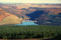
 Ladybower Resevoir |